->

31 May 2009

Nokia N97 Hunt - Clues 1,2,3,4 (UK Only)

Nokia N97 Hunt - Clues 1,2,3,4 (UK Only)

(Search for N)

Clue 1:
http://share.ovi.com/media/womworldnokia.public/womworldnokia.11602
(3,3,7)

Clue 2:

http://thereallymobileproject.com/2009/05/search-for-n-clue-2/
(3)


Clue 3: on this post (3 other parts needed)
(not a word but a format)

Clue 4: http://twitter.com/WOMWorldNokia
(5)


(no this is not photoshopped)

Clue 5: Unreleased yet.
(but predictable)


Enter your answers to the clues here
http://blogs.nokia.com/nseries/index.php/search-for-n
(mapperz has this confirmed by 4 green ticks


Please note: this is NOT the same clues for NokNok.tv running a similar competition (riddles only).

Source: (via email) +additional information:
"Actually, it isn't the WHOLE of the next clue, just a quarter of it you'll have to find the other three parts before you can crack it!
This is something of a collaborative clue, and you'll only be able to solve it by sharing what you have, and making sure you find the other parts. Good luck!

P.S. Clue number 4 will hit Twitter tomorrow afternoon, so keep an eye out."

Only helping out Nokia Hunters not the clever PR Spin from Nokia Marketing

Mapperz

well done royal mail - only 4 days late!

Search for N has been and gone - post was seriously late for this...


nice handwriting though....
Labels: , , , , , ,

29 May 2009

Up2Maps Thematic Maps Editor

Up2Maps Thematic Maps Editor

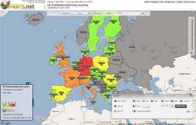
Up2Maps Europe - using Google Maps Flash API
Create Thematic Maps Fast with Up2Maps

Feature List
:
  • Maps can be exported to image (png) or embedded in blogs.
  • Data can be uploaded in excel files or typed directly in the application.
  • There are 2 levels of detail for each country.
  • Runs on Google Maps Flash API
  • Data includes territory names, zip/postal codes and international codification like FIPS and ISO.
Up2Maps Europe Editor
Map Editor - Build your own Thematic Map - Maps can be edited in many ways (colors, labels, legend etc)

Thanks to Moisés García
http://www.up2maps.net/

Ready Made Map EU Parliamentaries by Country
http://www.up2maps.net/maps/Gamusin23/Europe/ue_parliamentaries_by_country.html

Labels: , , , ,

Street View Denmark [Not Google]

Street View Denmark [Not Google]

Another excellent 'Street View' application from Denmark.

Street View Denmark [not Google]

Highly detailed panoramas 360 degree images seamlessly stitched and georeferenced form a nice interactive street view service for Copenhagen created by De Gule Sider AS

The user interface is friendly and easy to use, available in Danish or English


"using the
krpano viewer - is a small, versatile and high-performance viewer for interactive 3D panoramas on the web. It is based on the cross platform Adobe Flash Player."

Source:
Google Maps Mania
http://googlemapsmania.blogspot.com/2009/05/friday-fun-on-google-maps_28.html


Labels: , , , , ,

28 May 2009

Brand New Google Maps API v3

Brand New Google Maps API v3 (in Labs)

Just released... and its even faster....lots of code changes...
Google Maps API version 3 - Brand New

"Welcome to the release of version 3 of the Google Maps API. This JavaScript API will look similar to the existing version 2 of the Google Maps API. However, much has changed under the hood: Version 3 (called V3 within this document) has been designed to load fast, especially on mobile browsers such as Android-based devices and the iPhone™. The initial launch has a smaller feature set than that available in the V2 API. We will migrate additional features from V2 while working to keep the size of the JavaScript code small and maintain our optimized loading speeds. We welcome your feedback and comments on this version of the Google Maps API within the Google Maps API V3 discussion group."


Major Changes:
  • No API keys required! so can embed in RSS readers
  • Geocoding API has been overhauled!
  • Model–view–controller (MVC) based - so faster downloading javascript!

example of code changes:

function initialize() {
var myOptions = {
zoom
: 4,
center
: new google.maps.LatLng(-33, 151),
navigationControl
= false,
scaleControl
: true,
mapTypeId
: google.maps.MapTypeId.ROADMAP
}
var map = new google.maps.Map(document.getElementById("map_canvas"),
myOptions
);

More Information:
http://code.google.com/apis/maps/documentation/v3/
Official Blog Post:
http://googlegeodevelopers.blogspot.com/2009/05/announcing-google-maps-api-v3.html

Labels: , , , , , ,

27 May 2009

UK Broadband Notspots

UK Broadband Notspots

Lots of noise about where UK Broadband exists and does not exist - which is more important?

UK Broadband 'notspots' map

The UK Broadband Notspots (slow broadband or no broadband)
http://www.broadband-notspot.org.uk/coverage-map.html

Or by County
http://www.broadband-notspot.org.uk/maps-by-county.html

Define: Broadband
(typically speeds above 2mb bandwidth)

"The broadband comparison site SamKnows.com composed a connection map which shows graded postcode areas with a connection speed according to their distance from the UK's 5,500 telephone exchanges. Any more than 4km from an exchange and the speed drops below 2Mbps - but that's the case for 50% of homes in Basingstoke and about 25% of homes in Hampshire. Around 1% of UK homes can't get any broadband connection.

SamKnows co-founder Alex Salter said decent broadband has economic implications for both consumers and businesses. "In some cases people aren't able to shop online, aren't able to view certain websites or use social media applications such as Facebook and Twitter and they can't watch the BBC's iPlayer.

"It prevents flexible working. If the problem is fixed it means a lot more people could work from home which offers a very real way to improve society."

source: Jemima Kiss - Broadband Britain: Can you get 2Mbps? The Guardian

Media Coverage:
http://www.guardian.co.uk/media/pda/2009/may/27/broadband-digital-media
http://news.bbc.co.uk/1/hi/technology/8068676.stm

Labels: , , , ,

26 May 2009

Hypercities - Time Line Maps

Hypercities - Time Line Maps

A nice integration with a time-line and old maps.

Hypercities - Old Maps with Time-line
Using the time-line can narrow down dated maps for display in a particular city
More than one map can be overlaid and opacity can be controlled for each individual map.

Hypercities Maps in Rome
Rome has many old maps - worth checking out.

Note: There are option for 3D (GoogleEarth Browser plugin required) however the old map tiles do not seem to appear in the 3D version.

Timeline and Maps
http://linuxdev.ats.ucla.edu/

Source: Twitter (map search)

Labels: , , , , ,

25 May 2009

Google Maps Now Suggests Alternative Routes

Google Maps Now Suggests Alternative Routes

Google Maps Now Suggests Alternative Routes
Google Maps now in certain routes automatically creates an
alternative route.

This can be helpful for users wanting more choice when using the
driving directions from Google.
The 'suggested' option is currently available in Google Maps only
and not the Google Maps API.

The map above route with suggested routes is available with this link:

Dragging the routes is still available after a suggested route is selected.

Labels: , , , ,

21 May 2009

Google Maps API Adsense (Revamp) - May 2009

Google Maps API Adsense (Revamp) - May 2009

"a new feature that will enable geo developers to generate advertising revenue from their Google Maps API mashups"

Note: Google AdSense for Content account required to obtain a publisher ID

Mapperz Testing Adsense Google Maps API May 2009 Revamp
Live Example (few tweaks required)
http://mapperz.googlepages.com/Mapperz_Testing_Adsense_May2009.html

Sources: (and helped solved the issues)
http://groups.google.com/group/Google-Maps-API/browse_thread/thread/79da87885e4b879d#

Official Blog Post:
http://googlegeodevelopers.blogspot.com/2009/05/earn-revenue-from-your-mashup-with-maps_20.html


Labels: , , , ,

20 May 2009

Google Maps Data API - New!

Google Maps Data API - New!
(so new not had chance to play with it!)

Google Maps Data API - New!

Why Use the Google Maps Data API?

  • Storage scales simply with usage. You shouldn't have to worry about maintaining a data store to build a cool Google Maps mashup. Focus on building the client, and we'll provide hosting and bandwidth for free.
  • Geodata is accessible across platforms and devices. With many client libraries and clients, accessing stored geodata is possible from anywhere, whether it's on the web, a mobile phone, a 3D application, or even a command line.
  • Realtime geodata requires realtime indexing. For a lot of geographic content, freshness is important. Geodata from the Google Maps Data API can be instantly indexed and made searchable in Google Maps.
  • Rendering geodata is better and faster with the right tools. Through JavaScript, Flash, 3D, static images and more, we'll continue to provide better ways to render your content to meet platform and latency demands.

Some Applications That Have Already Been Made:

  • My Maps Editor for Android allows users to create and edit personalized maps from an Android mobile phone. Integration with the phone's location and camera makes it easy to document a trip with photos and text on a map.
  • ConnectorLocal is a service that informs users about the places where they live, work and visit by gathering trusted hyperlocal information from many sources. Using the Google Maps Data API, ConnectorLocal makes it easy for users to import and export geodata in and out of Google Maps, and also improves their ability to have data indexed in Google Maps for searching.
  • My Tracks enables Android mobile phone users to record GPS tracks and view live statistics while jogging, biking, or participating in other outdoor activities. Stored with Google Maps Data API, these tracks can be accessed, edited and shared using the My Maps feature in Google Maps.
  • Platial, a social mapping service for people and places, uses the Google Maps API to host geodata for community maps on both Platial and Frappr.
More information and Source:
http://googlegeodevelopers.blogspot.com/2009/05/
introducing-google-maps-data-api-in.html

Labels: , , , ,

Healthy Pet Mobile Vet - Service Area Map

Healthy Pet Mobile Vet - Service Area Map

Healthy Pet Mobile Service Areas Google Maps API
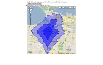
Brian Peyser has created Service Area Polygons for Healthy Pet Mobile Vet.
Provides both response by time and traffic overlay from New Market, MD.

Works really well:
how this was achieved?

"I did this with an adaptation of Marcelo's code:
http://maps.forum.nu/gm_driving_radius.html
I made the script return a pretty accurate set of points within the
limit of my algorithm based on both distance and time. You can see the results at:
http://www.healthypetmobilevet.com/area.shtml
Just keep this in mind--when I did a really accurate set of points it only took a few tries to exceed Google's limit. Also, it can take a little while to get the polygon. Make sure you've got it right before you start running the requests. When I did it, I actually made the polygons using OpenJUMP (which is a free GIS program) based on teh points output be the script, then converted to KML from Shapefile. You might be able to do this better than I did, but to get an accurate polygon you'll need a lot of requests. If you have a lot of regions to create it will take a long time, since you'll have to spread it over multiple days. However, you may be able to improve it by narrowing the search region. Instead of searching in a circle from each point, you just search a region that overlaps based on distance. In other words, do what you've already done to limit your search space."

If you want interactive 'Drive Time Zone' see the older post
http://mapperz.blogspot.com/2008/07/arcgis-javascript-extension-for-google.html

links to this:
Interactive ESRI Drive Time Google Map
Mapperz Version is based in Vancouver, Canada, but also covers the USA.
(Uses the ESRI ArcServer sample server as the backend for geoprocessing)

http://mapperz.googlepages.com/DriveTime_ESRI_GMAP.html*

*note googlepages will be closing 1st July 2009 - will move this demo by then and update the link.

source: Google Maps API group
http://groups.google.com/group/Google-Maps-API/browse_thread/thread/9ef5ee515db6fe07#

Labels: , , , ,

Ordnance Survey [resurrects] OpenSpace Mashup

Updated 20/05/2009
An the Winner is.... Gavin Brock -
Well done to everyone who contacted the Ordnance Survey about this - now you can be proud of yourselves.


The tiles impressions limit has also been upped to 1,000,000 from 30,000.
[http://www.brock-family.org/gavin/google-earth/osmaps.html]

2009-05-19 (Tue)

We’re back!

"First I would like to thank you all for your support! I believe that your emails, posts and comments, regarding yesterdays blog post, made a difference. It’s great to hear from you – it’s what makes writing software for fun, erm.. fun!

I just received a detailed message from the Director of Products at Ordnance Survey, apologising for the communication regarding the disabling of the service. He explained, that this is not a “derived data issue“, but rather to do with the licenses:"

more here: http://gavcode.wordpress.com/2009/05/19/os-overlays-re-enabled/


Ordnance Survey Kills OpenSpace
Mashup

update: Ed Parsons (former CTO at OS, now Google) mentions this mashup in his latest post
http://www.edparsons.com/2009/05/os-puts-the-no-back-in-innovation/

OS Kills OpenSpaceAPI G.Brock Mashup
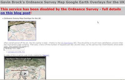
For a long time this site [http://www.brock-family.org/gavin/google-earth/osmaps.html] was straight forward and overlayed Ordnance Survey Maps in Google Earth.

Users could view the Maps which were overlay-ed on the Google Earth Terrain.
The 3D view helped visualize users with the surrounding features as well as giving them familiar maps as reference. There is no financial gain here, nor any advertising, but Ordnance Survey states

"We really like your project, but unfortunately it will need to be discontinued as soon as you can. This is because it remains our current position that OS OpenSpace Developers may use third party content with our data provided they do no grant the third party any wider rights than those the Developer agrees to when accepting the Ordnance Survey’s OpenSpace Developer Agreement."

OS, Openlayers [the underlying OpenSpace API source code] itself is third party [right?]

and JSR_CLASS.JS
is part of Yahoo! SDK Copyright (c) 2005, Yahoo! Inc.
[see http://openspace.ordnancesurvey.co.uk/openspace/opensourcelicences.html#anc1]

So what is wrong here?
Ordnance Survey you are not losing out here. In-fact it is a free promotion to use your service.

Brock OS disabled KML Tiles
The web version of the above site worked really well but not anymore - thanks OS.

Read more from the source:
http://gavcode.wordpress.com/2009/05/18/os-overlays-disabled/


Labels: , , , , , ,

19 May 2009

Wolfram Alpha Maps

Wolfram Alpha Maps

Wolfram Alpha Maps
The new 'computational knowledge engine' creates maps for distances between 2 locations in the world on the fly.

Example
http://www29.wolframalpha.com/input/?i=London+to+Sydney


For more tips on find out facts and geographical (geography) start here
http://www29.wolframalpha.com/examples/PlacesAndGeography.html

Labels: , , , ,

18 May 2009

+30 Top Mapping Blogs (Mapperz=7th?)

+30 Top Mapping Blogs">+30 Top Mapping Blogs (Mapperz=7th?)

Another debatable chart to comment on:

(All these blogs should be number 1.)

According to
http://www.whatsyourplace.de

"Selling the world parcel-wise on Google Maps and being an officially featured project on Google code, we closely follow new developments in the rapidly expanding market of Maps Mashups and the use of digital maps in general. Fortunately, there is a number of great blogs focussing on mapping issues. We would like to share our list of what we consider the top blogs on maps. The top ranking is in accordance with the number of google reader feed subscribers (shown in brackets) at the point of writing this post."

  1. StrangeMaps (13.576) - taking a humerous approach to map depictions - recommended: WW II - if maps could fight
  2. Google LatLong (5.350) - official blog edited by the Google Maps and Google Earth team - recommended: Whale Spotting on Google Earth
  3. Google Earth Blog (3631) - unofficial blog on everything Google Earth - recommended : 3 D Buildings Layer Update
  4. Ogle Earth (3448) - on how Google Earth and related products affect geopolitics - recommended: Exploring Shanghai’s recent geographic history
  5. Google Maps Mania (2915) - mostly edited by GMaps developer Keir Clarke focussing on maps mashups - recommended: Big Art Project on Google Maps
  6. The Map Room (2678) - map blog targeting wider audience - recommended: Is GPS accuracy at risk?
  7. *Mapperz (2131 >2,145 now) - introduces new digital maps - recommended: Africa in Open Street Map, lots of miles * (Still debatable on this - Mapperz)
  8. Spatially Adjusted (2067) - fairly technical GIS blog by professional James Fee - recommended: Licensing issues on the Geoweb
  9. Google Geo Developers (1924) - official blog - recommended: Solution to too many markers problem
  10. AllPointsBlog (1.290) - professional and high-frequency source on location technology. Recommended: Did Navteq really launch a rival to Google Maps?

  11. Free Geography Tools (951) - recommended: Google Maps Route Creation with NetKvik
  12. Virtual Earth (837) - An Evangelist’s Blog - recommended: MSN City Guides Relaunches
  13. GISLounge (656) - GIS information portal - recommended: Finding Bin Laden
  14. Very Spatial (565) - recommended: Digital Cities Concept
  15. Thematic Mapping (379) - focus on maps and economic/political development issues - recommended: Using KML at Thematic Mapping
  16. Programmable Web (34) -tremendous resource and catalogue of API-based mashups - recommended: WhatsYourPlace
  17. The Map Scroll (284) - nontechnological maps-blog - recommended: Taliban Influence in Pakistan
  18. Digital Earth (262) - personal blog focussing mostly on new developments in Microsoft’s and Google’s digital maps products - recommended Google Earth Imagery Update May
  19. Paul Ramsey’s GeoTips (259) - Founding Member of the Open Source Geospatial Foundation - recommended: Web Mapping Architecture at OpenGEO
  20. GeoThought (211) - blog on location technology by industry expert Peter Betty - recommended: The GeoSpatial Technology Revolution (Keynote)
  21. The Electoral Map (207) - focussing on the “intersection between politics and geography” - recommended: 2008 in political geography
  22. ManDown (176) - technical perspective on GIS, ESRI in particular - recommended: arcGIS Mobile 9.4 - Whats next?
  23. CartoTalk (122) - more a forum than a blog, but great place to follow qualified geo-discussions
  24. WebMapper (211) - focussing on the latest trends in location based services - recommended: UK Crime Maps scrutinized
  25. Spatiallaw (102) - low-frequency blog focussing on intersection of legal issues and spatial technologies - recommended: Why Spatial Law?
  26. What is Special About Geospatial (67) - Geo-student blogging about the geoweb - recommended: introduction of Pixelcase, where Photography meets Geoinformation
  27. Google Maps Gone Wild (60) - Examples about things one can do with Google Maps - recommended: recursive queries in Google Maps
  28. Mibazaar (57) - introduces practical Google Maps Mashups - Swine Flu Tweets on Google Maps
  29. atlas(t) (52) - recommended: Shoe Map
  30. WhatsYourPlace (19) - Google Maps Mashup Selling the World - recommended: Obamas Road to Presidency
  31. Geo2Web (16) - GIS technology blog - recommended: Mapping the Death Penalty
  32. Maps and Earth (4) - recommended: Find Custom Maps
source:
http://www.whatsyourplace.de/blog/?p=607#more-607

Labels: , , , , ,

14 May 2009

OffMaps - OpenStreetMap - iPhone

OffMaps - OpenStreetMap - iPhone

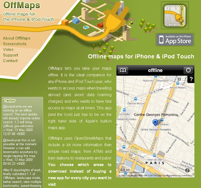
Offmaps OpenStreetMap on the iPhone

OffMaps allows you to access maps and location bookmarks wherever you are, even offline and abroad. This stores maps directly on your device for any area and zoom level you request. This gives you true offline maps for any region and city.

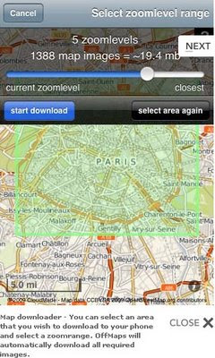
Offmaps OpenStreetMap on the iPhoneOffmaps OSM iPhone downloader
Image Sources: http://offmap.net/screenshots-offline-maps-appstore.htm

OffMaps does not come with one limited set of maps preloaded: It lets you download as many maps as you like for any area at no additional cost.

OffMaps has two modes: online and offline mode.

Online mode you can pan and zoom normally through the world map. Map images that have not been cached will automatically be loaded and saved to the cache for later offline use.
You can also search for locations around the world, add bookmarks and preload whole areas in a zoom range of your liking. Of course you can view your own location too.

Offline mode you can only view maps of areas that you have previously seen or preloaded. You can view your current location and bookmarks, but can't use the search as this requires the large CloudMade database that is only available online. You can even add local bookmarks by tapping the map at any location.

Features
OpenStreetMap Maps (Online Community Created Maps)
Maps with cache and download function
Online Search for places, cities and features
Bookmarks (offline and online) with internal search
Display of own current location with accuracy indicator
Map scale in kilometres or miles
Data roaming disabled (default), OffMaps will automatically go to offline mode when abroad.

For an Online Video of the map application see http://offmap.net/video-offline-maps-iphone.htm

Map source to see the level of detail:
http://maps.cloudmade.com

Source:
http://community.cloudmade.com/blog/2009/05/13/cloudmade-is-powering-the-1-and-3-iphone-apps-in-the-uk/


Labels: , , , ,

13 May 2009

Navteq Maps (Beta)

Navteq Maps (Beta)

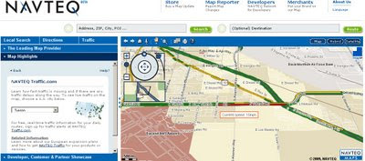
This is new. Navteq are know for their data but not for their mapping.
New Navteq Maps Beta 2009
New from Navteq, Maps not just data.

"Navteq today launched a beta showcase of its latest road navigation technology, as a clear rival to the Google Maps website"

Features:
  • Roads Map
  • Satellite Imagery
  • Hybrid Map
  • Routing with directions across the world (77 countries).
  • Live traffic [USA Only] (colour of average speeds coded)
  • 3D fly-through

Navteq Maps Beta Sign as real
Simple route London to Reading - with the 'Sign as real' function.

Note:
"one-click digital route maps to upload to Garmin, Navman, Navigon and, naturally, Nokia devices. (Nokia bought Navteq in 2007)"

Navteq Maps Beta Real-time traffic usa only
Live Real-time traffic USA cities only.

First impressions:
is this Map24?
The more you use it the better it becomes, there is a lot of data behind the scenes.
Trying to be Google Earth in the web browser?

Mapperz Source:
http://www.techradar.com/news/portable-devices/satnav/navteq-launches-google-maps-rival-598436

Labels: , , , ,

12 May 2009

Ordnance Survey Openspace API - UPDATED

Ordnance Survey Openspace API - UPDATED

Now include access to Ordnance Survey BoundaryLine [vector] Data

"Use the OS OpenSpace API to add Ordnance Survey maps to your website or blog."

Finally after many, many requests Ordnance Survey have updated their OpenSpace API which now allows adverts on your site!
See the OpenSpace API FAQ for more details on this

New Features:


Look-up services
  • OS OpenSpace boundary look-up
  • Postcode look-up
  • Place name look-up

A single API key may access data up to the following daily usage limits:

  • 40 000 tiles of mapping data in a 24-hour period.
  • 1 000 Place name look-ups (Gazetteer service) in a 24-hour period
  • 1 000 Postcode look-ups in a 24-hour period
  • 1 000 OS OpenSpace boundary look-ups in a 24 hour period
A New Gallery:

OS OpenSpace API Updated

The gallery includes projects like
Manchester cycling club (overlaying .gps routes on 1:50k mapping)

Satellite Dish Alignment (click UK Map to find the OS Mapping)

Whereisthepath (now 40,000 tile impressions per day due popularity - now using Google Appspot) *a Mapperz favourite all round mapping mashup.

Geograph Photos on an OpenSpace Map (Shows all the Geography photos - please do not use it to geo-locate photographs)

Public Footpaths [OpenSpace] on iPhone (designed specifically to be displayed on the Apple iPhone.)

Bike Hike (May 2009 update: Finding routes has been revised. Also revised so course points are now downloaded in GPX tracks and routes as waypoints)
Sky Cam (Latest skycam images using the Ordnance Survey OpenSpace Mapping)
Bikes & Boots (currently unavailable - Updated 12 May 2009)

Hill-baggin (Hill walkers and summit-baggers, attempting to provide accurate Ordnance Survey grid references for the 3000ft mountain tops, and prominent lower hills, of Scotland.)

Kent Trails
(Lots of trails [155 miles worth] in the County of Kent)

For more details and terms and conditions please see
http://openspace.ordnancesurvey.co.uk/openspace/developeragreement.html

Official OpenSpace API Demos - now including BoundaryLine data [wards, administration boundaries etc]
http://openspace.ordnancesurvey.co.uk/openspace/support.html

Thanks to Bill Chadwick [Whereisthepath author for the additional information]

Labels: , , , ,

Lake District Map - Updated +Heritage Paths Scotland Routes

Lake District Map - Updated + Heritage Paths Scotland Routes

The Lake District Map [3D] has been updated making over 70 different camera views available using a familiar nested link structure. User will find it a good way to explore the different features in the area.

Lake District Map Updated
Fly through tours guide you around the Fells, Lakes, Valleys and Villages of Cumbria, England.

Source: Email from Justin Farrell (Lake District Map Author)


Heritage Paths for Scotland

Another map has just been released from the Heritage Paths covering Scotland
(Heritage Paths Project - ScotWays - Scottish Rights of Way and Access Society)

Heritage Paths Map
View this Map: http://www.heritagepaths.co.uk/map.php?lat=55.85699&long=-2.142191
(use the slider to control transparency of the map tile layers)

This includes some unique features:
  • Roman roads
  • Drove roads
  • Pilgrimage routes
  • Miners’ paths
  • Smuggling routes
  • Trading paths
  • Military roads
  • Turnpike roads
  • Shieling paths
  • Peat-cutting paths
Source:
http://googlemapsmania.blogspot.com/2009/05/taking-high-road-on-google-maps.html

Well done to both for making this data available for all to use.

Labels: , , , , , , ,

09 May 2009

Society of Cartographers - CALL FOR PAPERS

Society of Cartographers - CALL FOR PAPERS

The Society of Cartographers [SoC] summer school is the UK's best meeting place for all those interested in any aspect of mapping. It is structured to include keynotes, presentations, workshops, debates, networking and social activities.

The deadline for expressions of interest is 30th May 2009.

Society of Cartographers - CALL FOR PAPERS


For More information and updates on this conference please visit:
http://www.soc.org.uk/southampton09/

The University of Southampton is the venue for the 45th Annual Summer School of the Society of Cartographers. The programme will be of interest for all involved in all aspects of the subject, with its well-established mix of lectures, workshops, visits and social gatherings.

The proposed session themes for this year's conference are:

* Symbolisation
* Routing
* 3D mapping
* Crowdsourcing data
* Transport mapping
* Emergency mapping
* Mapping for Wikispaces

Whilst a full programme has yet to be announced, just to whet the appetite the following speakers/talks have been confirmed:

* Edward Mac Gillavry, Webmapper "Collaborative mapping: flirting with the music
industry"

* Legible London - 3d mapping
* Cyclestreets.net - Routing for cyclists
* Keir Clarke, Google Maps Mania - "Geoblogging and Google Mashups"
* Cameron Balloons - 3d mapping to spheres and balloons
* Itoworld - Ideas in Transit
* MapAction - Emergency mapping
* Chris Osborne, cloudsourced.com - "Crowdsourcing geodata"
* Workshops agreed: Google mashups - OpenLayers

TO SUBMIT: email Steve Chilton with a title and a 100-200 word abstract.

Labels: , ,

06 May 2009

StreetVi (Alpha)

StreetVi (Alpha)

Find what is nearby?
StreetVi Alpha - Find what is nearby
Mixing StreetView, Birds Eye View and Google Maps with places Nearby.

Features:
  • Easy jump to city Street View
  • View the city from a bird's eye view (live search Bird's eye. if it's exists in the city)
  • Easy adding favourite places in the city.
  • Adding comments to a place
  • Wikipedia places (if not in your language link to translate google)
  • Photos nearby current location (panoramio)
  • Videos nearby current location (youtube)
  • Creation of thematic groups (for tours, for example "Best places of London", etc).
  • International project. Reviews in other languages translated via google translate.
Thanks to the creator Denis Lobachev.

Site: http://www.streetvi.com (in Alpha)

Mapperz

Labels: , , , ,

01 May 2009

ArcGIS 9.3.1 - GIS Data Portal - Share Geospatial Data

ArcGIS 9.3.1 - GIS Data Portal - Share Geospatial Data

ArcGIS 9.3.1 - GIS Data Portal
Find available datasets with the new ArcGIS 9.3.1 - GIS Data Portal

Version: 9.3.1.25

Features of the GIS Portal Toolkit Include:

Data Categories:
Web pages that help you discover and access a wide variety of geographic information for a particular data theme or data community.

Current Event or Application Topics:
Web pages that help you discover and access a wide variety of geographic information for a special application area or current event.

Search Page:
The Search page enables you to discover and access a wide variety of geographic information within the GIS Portal Toolkit. This geographic information, provided by government, commercial, and non-commercial organizations, includes map images, map services, geographic datasets, geographic activities, spatial solutions, clearinghouses, and land references.

Performing a Search:
To find content, you can set a search area by place name or you can use the Map Viewer to define your search. Once your search area is established, you can set your search criteria based on content type, such as map service, geographic datasets, activities, etc., data theme, keywords or date ranges. The results of the search are displayed along with metadata and if appropriate a map.

View Metadata:
You can use the metadata detail and the full metadata view to browse through information to locate what you are looking for. Map data can be viewed in the Map Viewer or with GIS software to display multiple data sources from the GIS Portal Toolkit along with data from local sources.

Map Viewer:
The Map Viewer tool allows you to interact with map services referenced in the metadata, and to browse through federal baseline datasets. The Map Viewer also allows you to save maps for later use, set transparency levels, query map information, and provides rich functionality to overlay map services.

Publish Data:
You can provide geographic data by publishing map services and images, geographic datasets, geoservices, spatial solutions, geographic and land reference material, and geographic activities or events to share with others through submission of on-line provider forms within the GIS Portal Toolkit portal. Publishing is performed via an online form or an upload utility.

http://gptogc.esri.com/GPT931/catalog/content/about.page

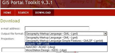
ArcGIS 9.3.1 Download data no shapefile?

Just odd that ESRI don't have ESRI Shapefile or File Geodatabase formats available... but do have their competitors formats...

A new version of http://www.geographynetwork.com/


source:
http://mandown.co.nz/esri/arcgis-9-3-1-arrives/ [Twitter Feed Sidebar]

On Friday, May 01 2009 At 9:10 PM
"Better to download than to get the DVDs by regular snailmail. I still do not understand why large software companies just stop to send DVDs by regular mail and just offer them for download instead. The copy protection is still the same and by using bittorrent- technology it will even go fast without too heavy load on their servers!"

Yes, why not save on costs and delivery ESRI and make your products download-able [with secure and authorized access]
All the Service Packs and Patches are only available as download (some are a big as the original installer too).

Labels: , , , , , ,