->

31 August 2010

The Future of Mobile Maps - Upnext

The Future of Mobile Maps - Fluid Mapping from Upnext

Today Upnext have launched their new iPad app with Fluid Labels.


Seamless integration with 3D Mapping, Map Overlays, real-time content.

The label system is now optimized for the iPad size. When you perform a search, multiple results populate the screen. As you move around the map, the results, smartly, refresh to give you more venues.

Category search or try using the Foursquare Friends checkins to really see the labels in action.

There are a couple more changes in this version. The Venue Info window has been enlarged and reformatted. Editorial and user reviews are now spread out in an elegant layout.

source:
http://techcrunch.com/2010/08/30/upnext-ipad-fluid/

Labels: , , , ,

30 August 2010

Embed MapQuest - New

Embed MapQuest - New
You can now add MapQuest maps to your blog or website.


How to do this:
Enter the location into New.MapQuest.com
Click the “Send To” button, then the “Your Website” tab
Copy and paste the code to your site.

"The MapQuest specific HTML code is written for you and all you need to do is add that text to your HTML source on your web page. This is useful for businesses, bloggers, or even hobbyists building your own website. Imagine making it easier for your customers to see where you are, and with a click or two, they can get directions directly to your location. This allows you to add maps instead of just links! This works for single locations, as well as routes. More advanced features for Embedded maps will be coming soon as we continue our fast, iterative feature releases."

Also includes the ability to pick your language, search and re-arrange saved locations within your ‘My Maps’ collections and more in-line help. We have also updated the ‘Send to’ feature to now support Garmin GPS devices and added the Embedded Maps option.


Source:

Labels: , , , ,

27 August 2010

Hurricane Tracker Bing Maps

Hurricane Tracker Bing Maps
*Hurricane Danielle is now a category 4 (major hurricane)

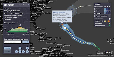
See current locations, forecast paths and detailed stats for any active hurricane this season (2010)

Hurricane Tracker Bing Maps
Currently Hurricane Danielle 2010 - Currently Category 4

  • Profile view of wind speed & forecast wind
  • Animated symbols
  • Lighten darken map
  • Possible forecast error shown
View the Hurricane Bing Map
http://www.msnbc.msn.com/id/26295161/

source:
http://bingmapswatch.blogspot.com/2010/08/hurricane-tracker-bing-maps.html


Another very good and interactive map to track Hurricanes is Stormpulse.

Hurricane Danielle Stormpulse Map

http://www.stormpulse.com/

Labels: , , , , ,

26 August 2010

Map Channels - Location Maps

Map Channels - Location Maps
*Using Google Maps API v3

Location Maps are simple controls to display a map of a single location. Street View can optionally be shown with the map.

Location Maps use the
Google Maps v3 API and are provided free for commercial or non-commercial use.

No adverts are included in Location Maps. An 'embed' control links from the map to this page.


Control size, maptype, map controls, markers and more with the new Location Maps which utilizes the fast v3 of Google Maps API.

Technical Notes:

You may copy the embeddable Location Map HTML Page to your own website (change the url used within the embeddable HTML code).

• Location Maps use the new Google Maps v3 API. This is more compact so loads faster.
• No API Key is needed for the Google Maps v3 API.
• The Street View is displayed without using Flash so no browser plugins are required.
• The 'fullscreen view' option included with the v2 API is not available. To see a larger street view click on the Google logo to see the street view at maps.google.com.

Full API reference can be found here http://www.mapchannels.com/LocationMaps.aspx#api


Labels: , , , , , ,

25 August 2010

ArcGIS Explorer (Build 1500) Released

ArcGIS Explorer (Build 1500) Released

ArcGIS Explorer Build 1500 Released

View OpenStreetMap in 3D (2d is default) via basemaps
ArcGIS Explorer Build Open Street Map in 3D

ArcGIS Explorer Build import your data
Import your .shp, .kml, .gpx, .txt, .csv or even File Geodatabases!

"KML improved; KML handling has been improved in both 2D and 3D mode, and regionated KML is now supported in 2D mode. KML interoperability has also been enhanced; notes can be shared (exported) as KML and KML can be shared (exported) as layer packages or converted to notes. The KML file association can be set to ArcGIS Explorer.

Symbols (more); ArcGIS Explorer symbols have been updated to improve appearance in 2D and 3D modes. Symbol management tools have been enhanced with improved support for custom (user) symbols."

Buffering a point by 100km is possible via Analysis

ArcGIS Explorer Presentation Slide
Create driving directions, add slide (like screen grabs) to presentation - playback is full screen and glides to various screen grabs.

ArcGIS Explorer features new capabilities that enhance interoperability with the ArcGIS system and KML. These features include:

ArcGIS Online integration
Support for ArcGIS Explorer Online maps, including presentations and notes
Share (export) to layer package or KML
Create notes from features
Create notes from KML
Add data directly from Excel spreadsheets

Download here [98.4mb]:
Useful Links

Source:

Labels: , , , ,

23 August 2010

Spatial Data Viewer on Bing Maps App

Spatial Data Viewer on Bing Maps App

View
  • ESRI Shapefiles (.shp & .dbf files) [best under 300k]
  • GeoRSS Feeds (.xml with lat & lng)
  • Well Know Text (WKT)
Known as Ricky's Data Viewer
Bing Maps Shapefile Viewer
Loaded Shapefile (World Countries) in the Data Viewer using 'select shapefile' option, .dbf if your want to see attributes (table data).

Bing Maps Viewing GeoRSS Feeds
GeoRSS (.xml) recent earthquakes feed from (USGS)

Full list of Bing Maps Apps.

Labels: , , , , ,

20 August 2010

100 Million Google Mobile Map Users

100,000,000 Google Mobile Map Users

Almost five years ago, Google launched Google Maps for mobile to help you get where you needed to go from your phone instead of a paper map.

Today, more than 100 million people a month are now using Google Maps for mobile to get from point A to point B, find nearby places, and more.

Over the past 5 years, Google Maps for mobile has changed quite a bit they are adding more ways to help you explore the world around you. There is My Location, you can quickly find where you are on the map with or without GPS. You can put your friends on the map with Latitude. Navigation even turns your phone into a free internet-connected 'SatNav' with voice guidance and Street View imagery.

Google Maps Mobile History 5 Years
Google Maps Mobile - The 5 Year Journey of Advancing Map Updates.

Lately, has seen some changes especially focused on helping you find the right place at the right time. With recent additions such as Place Pages, you can now pick a nearby place by browsing information such as opening hours and review snippets for the places around you.
It’s easier than ever to find those places with Search by voice or the new Places icon on Android. With this latest Android version, happy to see that you’re now searching for places almost three times as often, doubling how many Place Pages are seen a day.

Source & Image:
http://googlemobile.blogspot.com/2010/08/to-100-million-and-beyond-with-google.html

Labels: , , , , ,

19 August 2010

Open Street Map Routing, Directions & Export

Open Street Map Routing, Directions & Export

OpenStreetMap (OSM) gets even more powerful with directions and routing tools.

Find, View and Export your custom directions
.

Designed Routes for:
  • Car
  • Heavy Goods Vehicles
  • Goods Vehicles
  • Public Service Vehicles (Buses)
  • Motorcycles
  • Bicycles
  • Pedestrian
  • Moped
OSM Powerful Route Finder
Simply have a start and end location - midpoints/waypoints can be included.

OSM Directions of Route
Directions 'explain' your routes, like a satnav would, turn by turn, includes all road names.

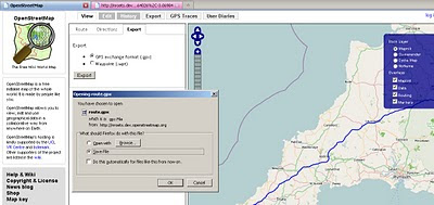
OSM Export Your Route
Export, a very useful component lets you export in GPS exchange format (.gpx) or waypoints (.wpt) format.

The map with route (above) example:

http://nroets.dev.openstreetmap.org/demo/index.html?lat=54.6&lon=-3.8&zoom=5&layers=B000TTTTT&v=motorcar&adj=recommended&markers=!50.06626%2C-5.71482!58.64026%2C-3.06984

Click 'Recommended' to calculate the route.

Labels: , , , , ,

17 August 2010

BBC Dimensions (Prototype) Mapping

BBC Dimensions (Prototype) Mapping

BBC Dimensions is an experimental prototype for the BBC. We want to bring home the human scale of events and places in history. The D-Day landing beaches measured from London to Norfolk in the UK. How far would the Titanic stretch down your street?

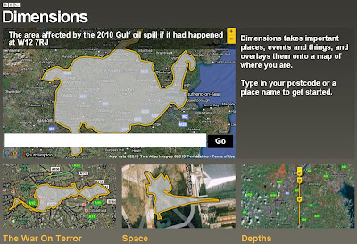
"Dimensions simply juxtaposes (side by side) the size of historical events with your home and neighbourhood, overlaying important places, events and things on a satellite view of where you live. Certain "Dimensions" can be transformed into short walks, so you can get a physical appreciation of the distances involved."


BBC Dimensions howbigreally map
Use your Postcode or Town to recenter the map and see in scale terms historical events with this map tool.

How do you make the Dimensions maps?

We've built a system that can quickly take scale illustrations of historical events and superimpose them on zoomable, clickable maps. Information designers at the BBC research and produce these illustrations based on a range of library and on-line resources to make them as accurate as possible. If you think it got something wrong, get in touch. http://howbigreally.com/contact/

BBC Dimensions example maps

More Examples of events across the globe are available.

Can I make a Dimensions map?

The BBC hope to open up the ability to create Dimensions maps in a future version, so that local historians, experts and enthusiasts can use it as a tool for communicating what they know.

What's next for Dimensions?

BBC will evaluate the prototype based on your feedback, and hopefully integrate it into the BBC's online history and news coverage

Try the BBC Dimensions (Prototype) Mapping

http://howbigreally.com/

Labels: , , , ,

16 August 2010

Open Layers Heatmaps

Open Layers Heatmaps

"Making Open Street Maps even hotter!"

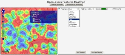
Open Layers OSM Heatmap
A Great Mashup to show 'HeatMaps' using Open Layers and Open Street Map Features (OSM).
Select a number of OSM Features and create dynamic heatmaps from them.
Note: this is the 'inverted' heatmap view.

Credit to Felipe Barriga (http://blog.felipebarriga.cl/)

If you want to create your own HeatMaps the source code is available via OLHeatmap.


What is OLHeatmap ?

OpenLayers Heatmap is a group of hacks ( talented programmers) to render heat maps over OpenLayers. At this moment is very ugly and dirty but I have some ideas in mind to make this a more presentable project....

Why that name ?

OLHeatmap stands for OpenLayers Heatmap

Video Demo


Video via http://opengeodata.org/osm-heatmaps-in-the-browser-w-openlayers

Heat Map
http://blog.felipebarriga.cl/olheatmap_demo/

Source:
http://blog.felipebarriga.cl/programacion/olheatmap-live-demo/

Labels: , , , ,

12 August 2010

Sports Tracker 3.5 Released

Sports Tracker 3.5 Released

Sports Tracker
The Award winning FREE Sports Tracker Application gets an update along with revamped web service for viewing and sharing your routes.

"The newly launched online service allows users to store, visualize and analyze their workouts with enhanced tools, as well as share their media enhanced workout experiences with other Sports Tracker users - and the whole world. The online service also allows existing Nokia Sports Tracker Beta users to import their workout history to the new service.

The Sports Tracker mobile application has also been updated to support uploading of tracked data to the new service and direct sharing to Facebook. The update also extends the list of compatible devices to cover more than 50 device models."

Testing the New Sports Tracker:
Sports Tracker 3.50 Mapping GPS Routes
Mapperz has tested this and the services along with the phone application works seamlessly together.

With the FREE Sports Tracker application mobile phone becomes a full-featured GPS sports computer, keeping track of everything from calories burned while running to your average cycling speed over altitude. You get maps, time and distance calculators, step count, and even heart rate when you use a compatible Polar HR belt. You can chart your progress, find your strengths and weaknesses, and share with others.

The new mobile application allows users to:
  • Record activities with all the data needed to analyze the performance, including distance, speed, duration, route, step count and more.
  • Check their location on the map while running, cycling, walking or with any other outdoor activity, using Open Street Map as a map based (can be cached for offline use)
  • Upload their activity data from their phone to the Sports Tracker service
  • Share their activities and automatically geo-tagged photos with other users and friends on Facebook, directly from their phone
  • Optional with Heart Monitor - Record heart rate data by connecting the Polar WearLink®+ transmitter with Bluetooth® heart rate belt by Polar (€70 or $90USD)
  • Automatically compare speed, distance and duration of recorded activities


Get it here:
http://www.sports-tracker.com/

With this Launch Ovi (Nokia) are having a competition:


GPS Trace from Skating
Create your own shape and enter for a prize. Image: Ovi Blog

"What we’re asking you to do is simply this: make a funny or interesting shape with your Sports Tracker workout, share it publicly in the service and send a link of the shared workout to us."
For more information on this competition and what can be won go here:
http://blog.ovi.com/2010/08/12/sports-tracker-ovi-competition-launches-now

Labels: , , , , , ,

10 August 2010

MCZ Project Interactive Map

MCZ (Marine Conservation Zone) Project Interactive Map

MCZ Project Interactive Map
Find a huge amount of maritime information, this example shows bathmetry and ship wrecks along the coast of the SW England..

But this map project goes much further:

This project has been jointly funded by Defra, Natural England and the Joint Nature Conservation Committee.
MCZ Project Interactive Map Marine Species
The map contains a huge resource of Marine and Coastal Zone data from Tide Wave Projects to reported Species of marine life surrounding the diverse waters of the United Kingdom.

What is the MCZ Project Interactive Map?

The Interactive Map is a web based Geographic Information System, which is essentially a way of displaying interactive maps online. The MCZ Project Interactive Map allows you to view maps of the United Kingdom and display additional relevant information above it, using layers selected from our marine spatial planning database. The tool also allows you add your own information to the map by drawing and labelling areas that you use or have information about. The MCZ Project Interactive Map is based around the Open Layers interface which is similar to Google Maps, and in many cases the controls will be exactly the same. This similarity will be become apparent as you start to use the tool.

We are using the Interactive Map to achieve two goals:

  1. To communicate the diversity and range of information that is being used by the MCZ Project. We hope that you find the investigation of the spatial data to be an interesting experience and that you discover more about the relationship between mankind and the coasts and seas of the United Kingdom.
  2. To collect information from commercial fishermen who are using the seas around England; however this may be extended to other stakeholder groups such as sea anglers and SCUBA divers. Using the Interactive Map, users can draw and label areas they use or places where they know certain species and habitats occur.
Map Help - and you can become and editor!
http://www.mczmapping.org/WebHelp.aspx#1

View the MCZ Project Interactive Map
http://www.mczmapping.org/#

This Map is another Open Street Map based project

Labels: , , , , , , , , ,

08 August 2010

Society of Cartographers Annual Conference - September 2010

Society of Cartographers46th Annual SoC Summer School

8-10th Sept 2010

University of Manchester


The 2010 Society of Cartographers Summer School will be held at the University of Manchester from Wednesday 8th September 2010 to Friday 10th September 2010.


The venue in Manchester is the University’s Chancellors Conference Centre, with lectures, accommodation, meals, and social events all on a single site. The Annual Summer School is open to members and non-members and is usually held over four days in September at a different location each year. It creates an ideal opportunity to attend lectures, exhibitions, seminars and workshops, as well as to visit a broad spectrum of cartographic establishments. The friendly and relaxed atmosphere is also ideal for informal discussions with fellow cartographers and is a pleasant and stimulating way to keep up to date with new technology. It is especially beneficial for those cartographers working within small cartographic units who can perhaps remain isolated from new developments and trends within cartographic circles.

The 2010 conference themes this year will include:

  • Art and everyday mapping
  • OS OpenData
  • Maps and geopolitics
  • Transport mapping
  • Mapping Manchester
  • Crowd-sourcing and open data

The Wednesday afternoon starts off with three lectures to set the cartographic scene, focusing on the mapping history of Manchester and showcasing examples of current Manchester-based map design. This is followed by papers on the geopolitics of mapping, focusing on the changing political life of a single map, the geopolitical significance of media mapping and a new school-based mapping initiative.
On Wednesday evening the popular quiz will be held in the bar in the Conference Centre.

On Thursday morning the focus shifts towards design and practical aspects of production, with sessions on transport mapping, followed by an opportunity for delegates to share their own practical experiences in a members session. In the afternoon the programme moves on to some of the challenging ways maps are being deployed in wider social contexts. Three papers around everyday encounters with urban life chart psycho-geographical use of maps and explore the potential of community mapping initiatives. These are followed by a session on modern art and the map, including embodied and performative cartographies. The day concludes with the conference dinner in the evening.

On Friday papers focus on the twin challenges of Opensource data and crowdsourcing. Three papers explore OS Opendata, its politics, qualities and applications, before a concluding session where the wider implications of crowdsourcing are explored. A final session offers opportunities to reflect on the Summer School with panel discussions relating to issues brought up during the three days.
If you would like to become a member of the Society of Cartographers or explore the benefits of membership, please visit our website at http://www.soc.org.uk
Full Details on this event at:
http://www.soc.org.uk/manchester10/

Labels: , , ,

05 August 2010

UK SiteSeeker (Beta) Map

UK SiteSeeker (Beta) Map

"Whether you're a seasoned camper, caravanner or motor caravanner, or new to taking your accommodation with you, the Club will help you to get more from your caravanning and camping holidays. "

Find Electric Hook-ups, HardStanding, Full Service within a search radius from 5 miles to 50 miles using this help map.
SiteSeeker Caravan sites Google Map cornwall within 10 mile radius
Find Caravan electrical hook up sites using the Map


Modify your search even further with the 'choose facilities' option at the bottom of the map.

Try the interactive map here:

Labels: , , , ,

03 August 2010

Open Street Map now in Bing Maps

Open Street Map now in Bing Maps

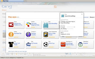
Open Street Map is now available in Bing Maps via the 'Open Street Map' App

Open Street Map now in Bing Maps
MapNik Tile Render via Bing Maps (OSM) APP


Open Street Map now in Bing Maps

http://www.bing.com/maps/explore/#5003/0.6002=
q:NYC:nelat:51.6120377517871:nelong:0.18654357910159:
swlat:51.4079622462129:swlong:-0.446543579101535:nosp:0:adj:0/5872/style=Mapnik&lat=40.65415&lon=-74.024291&z=11&pid=50735

In Addition there are some improvements to Bing Maps Explore:

  • Appearance: Cool colours create a more visually appealing backdrop that helps content ‘pop’ on the map, providing clear differentiation for pushpins, labels and red, yellow and green traffic overlays. 
  • New labels: Larger fonts correspond to larger roads, making it easier to identify major streets and throughways. Crisper labels eliminate the need for bolding and less-attractive glows, allowing users to quickly find locations in a relevant format.
  • Improved international coverage: Data updates deliver improved road and street detail across Central and Eastern Europe, the Middle East, Oceania and Asia.
  • Dynamic Labels (beta): This innovative map navigation allows you to quickly zoom to a region or location on the map with just a few clicks, making it easier to identify and explore areas or neighborhoods of a city. Turn on the dynamic labels beta from the map style selector on bing.com/maps/exploreand labels become clickable.

Labels: , , ,